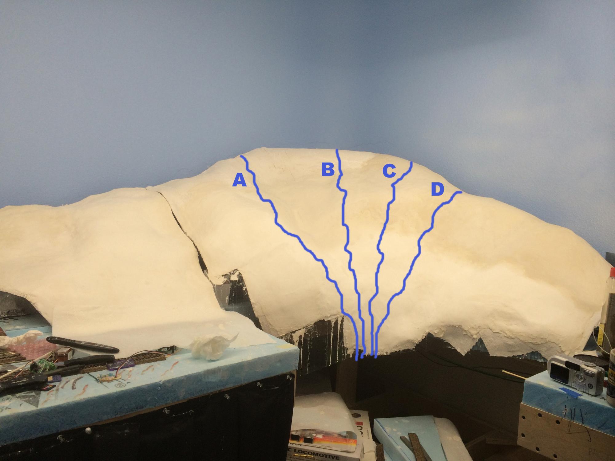
Where to put the stream / waterfall? Considering the room and postion of the mountain, what is the best position? Thanks!

Position "A"
27% (6 votes)
Position "B"
14% (3 votes)
Position "C"
18% (4 votes)
Position "D"
41% (9 votes)
Total votes: 22
| Attachment | Size |
|---|---|
| mtplasterwork_7-31-15mu.jpg | 202.84 KB |
| mt_room.jpg | 517.54 KB |
>> Posts index
Navigation
Journals/Blogs
Recent Blog posts:
Comments
Where it would naturally flow...
Its hard to tell exactly where it would be looking at 2D photos, but I would want the stream to be wherever water would naturally flow down your mountain if it were to rain on it.
Randy
B&O/PC Cincinnati West, Summer 1975
http://model-railroad-hobbyist.com/node/17997
"Considering the room and
Water would probably collect somewhere near where all the lines meet at the toe of the hill so a drainage ditch or stream head there might make sense. Water always flows perpendicular to the contours, when in doubt draw them in and then draw the flow at right angles to each point along the contour.....DaveB
Read my blog
Easy way to see would be to
Easy way to see would be to mist the mountain with wet water or alcohol and see where it drips. You will then be sure to have all of the irregularities covered. If you are going to model a year round waterfall I would have it's source somewhere other than the top of the mountain. The source could be a subterranean spring at least a third of the way down the slope other wise there will only be water after a rain as how else would it get to the top of the hill? To take a guess from the photo I would go with the crevice between A and B with the idea that the water from the areas A, B and C would likely drain into the stream and that D would likely have a trickle on it's own.
Rob in Texas
https://model-railroad-hobbyist.com/node/43245
prep for an operating session • Delving into the past • The club blog
https://www.youtube.com/channel/UCDmC2GjPPfARE7xdZPSjGaw/videos
http://www.etmrc.org/
Some waterfall info
https://en.wikipedia.org/wiki/Seven_Falls
I've been here, maybe it will help you pick out a spot
James Eager
City of Miami, Panama Limited, and Illinois Central - Mainline of Mid-America
Plant City MRR Club, Home to the Mineral Valley Railroad
NMRA, author, photographer, speaker, scouter (ask about Railroading Merit Badge)
None of the above
Water will always flow down the path of least resistance. None of options A - D follow that principle. The origin of your stream should start at a low point where trickles of water from above will naturally congregate. Or as suggested above the origin could be a spring.
Peter
The Redwood Sub
The only ways you're going to
The only ways you're going to get a stream flowing from those positions is if you have:
A: Snow melt or a glacier at the top of the mountain, or
B: Geology that permits an Artesian spring - Basically, a porous rock layer at the top of the mountain that contains an aquifer that is pressurized from a higher point in the aquifer layer - usually through a fold in the rock ( which should be reflected in your rock strata, if exposed.... ), or some kind of erosion. Even then, a spring at the top of a mountain/hill is very unlikely.
https://en.wikipedia.org/wiki/Artesian_aquifer
...or
C: A current Modeler's Creative Geology license. :)
-----
Read my Journal / Blog...
Digitrax & JMRI NRail T-Trak Standards
T-Trak Wiki My T-Trak Wiki Pages
A lot of streams just start
A lot of streams just start right out of the ground. So you could have the stream where ever you want not just starting from the top.

Amherst Railway Society HHJ YouTube channelNone of the above
Water erodes rock.
That makes valleys.
None of your options are in a valley.
All options will look odd.
Your mountain is shaped wrong for a water fall. The mountain should be a ridge, not a peak and there should be a fault or gap in the ridge, the stream waterfall flows through that gap.
At least that's the way Mother Nature has been doing it over the last million years or so.
Dave Husman
Modeling the Wilmington & Northern Branch in 1900-1905
Iron men and wooden cars.
Visit my website : https://wnbranch.com/
Blog index: Dave Husman Blog Index
Follow the existing contours
Assuming that we decide that there is a spring, or some such, near the top of the hill, the water will find it's own path. Looking at the mountain it seems like there is a bit of a depression that might hold the stream.
Maybe try rolling some marbles, less messy than liquids, down the hill and see where they want to go.
At any rate, it is looking good so far.
Rick Reimer,
President, Ruphe and Tumbelle Railway Co.
Read my blogs
Don't overthink it
Rick:
Assuming there will be some more elevation depicted behind the 3 D portion, have it appear from behind position D. That's the lowest spot visible on the ridge - I'd expect any water to find that spot and flow there.
Jerry
Add a Saddle or Notch
I agree that none of the options will look natural. Water just doesn't flow from the top of a ridge like that. If you really want a waterfall or stream coming all the way down the mountain the best option might be to add a saddle or notch so the water is not flowing from the highest point. Failing that, you could hide the source in among trees if it's a heavily forested scene.
Dave
I'll be hiding the source of
I'll be hiding the source of the stream with trees and foliage so it should look natural.
Rick
The Richlawn Railroad Website - Featuring the L&N in HO / MRH Blog / MRM #123
Mt. 22: 37- 40
It'll be interesting to see
It'll be interesting to see how you do this. I've never done a waterfall mostly because I can't come up with a logical reason why there should be a waterfall in the first place. Most waterfalls would take a good sized river to feed them and I just don't see that much water coming out of a hole in the ground. So I'll be watching you !
!
Michael
The Georgetown & Allen Mountain Railroad
Here is something to consider
Here is something to consider, Hickory Nut Falls in Chimney Rock, NC
Bill Michael
Florida East Coast Railway fan
Modeling FEC 5th District in 1960
While not as dramatic as Chimney Rock, NC
Rick,
Check out Tahquamenon Falls, State Park Michigan. Perhaps the Bing images will help some. The Upper Falls only have a 48' drop (6 3/4" drop) and surrounded by trees,
Charlie
Doesn't have to be much water
I think Don has a good suggestion but I too would conceal the source. Personally I wonder why you didn't take advantage of the notch created at the module joints and follow the spillway at the seam.
Foliage appropriate for your area of course! I'm anxious to see this develop.
Neil
Neil Erickson, Hawai’i
My Blogs
Waterfalls
Note that in both falls pictured the stream does not start at the point of a mountain. In the NC example it is flowing off a plateau and the ground rise to the left. In the tropical example it is from a shallow valley, the ground slopes up from both sides of the stream.
Its his layout, but he did ask what would look best. Answer, that's not a landform that would look good with a waterfall.
Dave Husman
Modeling the Wilmington & Northern Branch in 1900-1905
Iron men and wooden cars.
Visit my website : https://wnbranch.com/
Blog index: Dave Husman Blog Index
with tongue in cheek I would
with tongue in cheek I would recommend placing it somewhere on the layout. Seriously, follow the contours.
I have noticed that you tend to follow my chaos theory of item storage.
Rich S.
Home of the Here N There RR (N) (under construction)
One of these days I'll be able to run some trains!
Now on Facebook for whatever that's worth.
Falls
This is Bridal Veil Falls in Telluride, CO. It flows from a notch at the base of a V shaped valley.
Dave
Thank you all for your votes and input!
I decided to place the waterfall more or less in the "A" position mainly because the natural contours of the mountain seem to suggest a place where water would run down the mountain. The picture I originally posted on this poll didn't really show that well, but in person it looks obvious.
I added a couple of pictures on my other thread about the mountain project. You can see them on Page 6 of the thread. To go to the thread click HERE.
Rick
The Richlawn Railroad Website - Featuring the L&N in HO / MRH Blog / MRM #123
Mt. 22: 37- 40
Art and Geology
Actually, I'm puzzled by the options, because while the slope is steep, I don't see where any fall would be, other than a series of rapids. I'm assuming the questions raised here by the practical minded can be addressed by a backdrop painting and trees. From an artistic standpoint, I'd choose B, as it is the focal point of that section. However, I'd also take a hammer and redesign the mountain-- something along the lines of Bridal Veil in Yosemite:
Note that from the point of view of someone in the valley, the water does flow from the top (but not the peak) of the mountain. A more distant view (shown on your backdrop if at all) reveals the geology needed to support such a magnificent cascade. You are building an eye level layout, so the left picture is appropriate.
Whatever you decide to do, make it spectacular. After all, you have to look at it for the next 20 years.
pqe
Looks like you're getting there
To me, the old waterfall in your Georgia Misti Mountain appeared quite realistic. I suggest study that and see how it would transform on the new mountain.
P.S. I do believe you meant obvious?
Bill D.
N Scale (1:160), not N Gauge. DC (analog), Stapleton PWM Throttle.
Proto-freelance Southwest U.S. 2nd half 20th Century.
Keep on trackin'
Thanks, UP Willy!
For the encouragement and spelling correction. While both in Hawaii and Alaska I saw dozens of examples of hillside streams running down a grade that was much less than 90 degrees. The waterfalls on those streams were where the streams ran over jutting rock formations - much like I portrayed on the previous Misti mountain.
Rick
The Richlawn Railroad Website - Featuring the L&N in HO / MRH Blog / MRM #123
Mt. 22: 37- 40
the oddfall of the bunch?
For a waterfall without a river feeding it check out Mossbrae Falls at Dunsmuir. It runs out of a porous river bank into the Sacrament river paralleling the SP tracks in the narrow canyon.Looks a lot like something a modeler might dream up.........DaveB
Read my blog