Peering into the Mists of Time
(Finding Historical Sources of Information)
Model railroading has many choices that are available to a hobbyist, the choice ranges from what era to what exactly are you trying to model and to do a prototype or not. My choice to prototype a major railroad that had a route go through my hometown of Piedmont, MO was pretty simple. I decided to base my layout during 1881 with the St. Louis, Iron Mountain, and Southern Railway. At first, I thought that finding information like schedules and the equipment used was lost to the mists of time, but the more I researched the easier it was to find the information I was looking for.
Many hobbyists shy away from doing 19th century prototyping because they are under the impression that records like schedules and what equipment was used by railroads from that era do not exist or have not survived to our modern era of information. This is not the case. Many of the books that travelers and railroad companies used have survived into the modern era of the information superhighway. There are two specific series of periodicals that were published in the latter half of the 19th century that have been digitized and saved for reference of our generation.
The first series of books that is helpful is simply titled Travelers’ Guide of the Railway and Steam Navigation Lines of the United States and Canada. This series of books was published monthly from the 1860s up until the early 1900s. They were originally published by Rand McNally Corporation and provided the traveler an invaluable resource of planning a trip using railroads and steamships to get where they wanted to go. The books have every railroad’s schedule published as well as a map of all the stops that the railway had a depot at. The schedule detailed the times of arrival or departure plus what amenities were available to the traveler such as Buffet Cars and Sleepers. Along with the schedule was the notation of which stations had a telegraph and if the route was daily, every day except for Sunday, and if it was an Express, Passenger, or Mixed train.
This was extremely helpful for me when it came to set about what stops I wanted passengers to get on and off the trains. It would also be helpful for when I wanted to do operations. In the July 1882 issue, the stops that SLIMS made were St. Louis Union Depot, St. Louis Plum Street Depot, Carondelet, Docks, Jefferson Barracks, Quarantine, Cliff Cave, Jefferson, Montesano, Kimmswick, Sulphur Springs, Glenwood, Illinois, Pevely, Horine, Crystal, Bailey, Hematite, Victoria, De Soto, Vineland, Blackwell, Cadet, Mineral Point, Summit, Hopewell, Irondale, Bismark, Iron Mountain, Middlebrook, Pilot Knob, Ironton, Arcadia, Hogan, Ozark, Annapolis, Des Arc, Piedmont, and so on all the way to Texarkana.
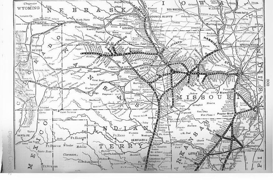
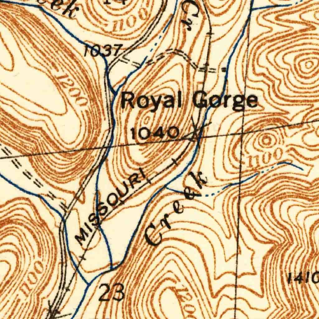
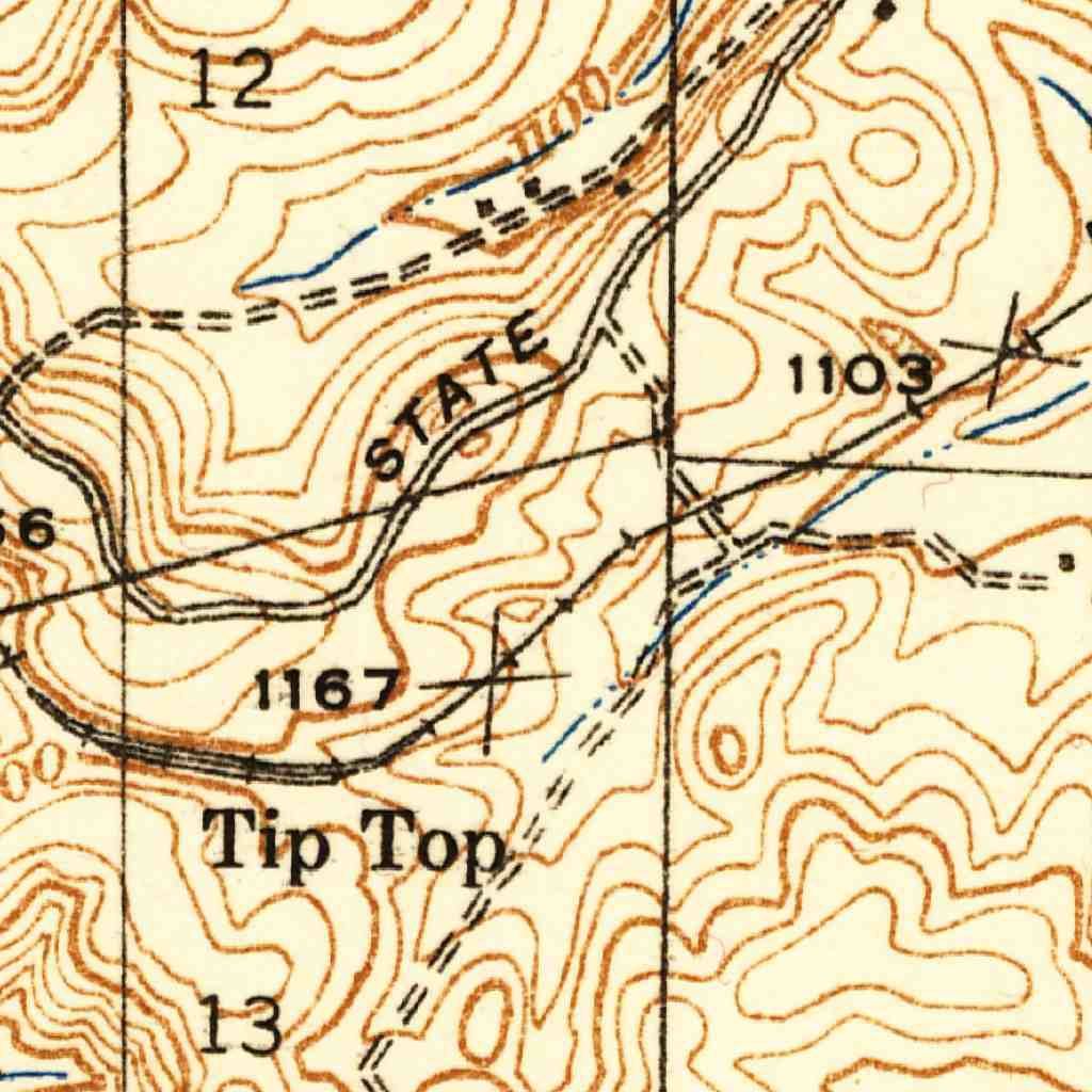
Since my hometown is Piedmont, I want the end of the line to be there and the start of the journey to be St. Louis’s Plum Street Depot. This leaves me with quite a few stops, too many to model on a model railroad, so I cut our a good portion of the stops to end up with Piedmont, Des Arc, Arcadia, Iron Mountain, Bismark, Irondale, Mineral Point, De Soto, Victoria, Jefferson Barracks, and St. Louis Plum Street Depot. I wanted to include as part of the scenery two areas that really showcases how rugged the Ozark Mountains can be, so I added Royal Gorge and Tip Top to my list. The section of track at Royal Gorge is an S curve that winds between two mountains that rise from 900 feet to a staggering 1200-1400 feet at their tops. A creek runs parallel and at one point a railroad bridge crosses a fork of the creek. Tip Top is important as it has the mainline in the center and a siding on both sides.
Now that I have the information about the stops and the features I want to include, I visited the US Geological Service’s web site and downloaded historical maps of the areas of the places. This allowed me to see how SLIMS had laid their lines. This is where I discovered Royal Gorge and Tip Top and saw how majestic it must have looked when the USGS surveyed the area.
The final list of scenes is:
1. Piedmont (Sawmill)
2. Des Arc (Logging Camp and Stockyard)
3. Royal Gorge
4. Tip Top
5. Arcadia (Slaughterhouse)
6. Iron Mountain (Iron Mine)
7. Bismark (Icing Platform)
8. Irondale (Iron Mine)
9. Mineral Point (Silver and Lead Mine)
10. De Soto (Railroad Car Shop and Roundhouse)
11. Victoria
12. Jefferson Barracks
13. St. Louis (Lemp Brewery, Warehouses, Smelter, Lumberyard, and Plum Street Depot)
Armed with this information, I now needed to know exactly what equipment SLIMS had and found The Official Register of Railway Equipment. One edition is from June 1903 and the other is from 1904. This is close enough to the year I want to model. The section on the Missouri Pacific SLIMS branch has a table of all the freight cars, their type, dimensions, capacity, and how many they actually owned. Also included in the table is the range of car numbers they used. On the next page of the book there is a list of how many cars and the numbers of the cars related to passenger travel. The table also includes how many of each car type the railroad had.
A real special treat was to see the sleeper cars and their names that were owned by the Missouri Pacific. Missouri Pacific was engaged in a series of legal battles, in the 1880s, with The Pullman Company regarding the use of Pullman cars on SLIMS after Missouri Pacific had acquired the railroad. MoPac had a contract with The Pullman Company allowing the use of Pullman cars on the railway, but SLIMS did not. The Pullman Company was trying to force MoPac to use Pullmans on their SLIMS division. In the end, the Supreme Court of the United States ruled in favor of MoPac by saying that SLIMS was not required to have Pullman Cars on their route.
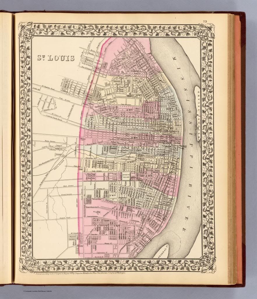
I got maps of St. Louis from 1871, 1880, 1894, and 1898 from The David Rumsey collection at http://www.davidrumsey.com. These are high quality maps that were published in those years that give a glimpse of what St. Louis was like in that time. One of the maps shows all the trolley lines that ran through the city. The map I used was the 1880 one since it is the closest to the year I set for my railroad.
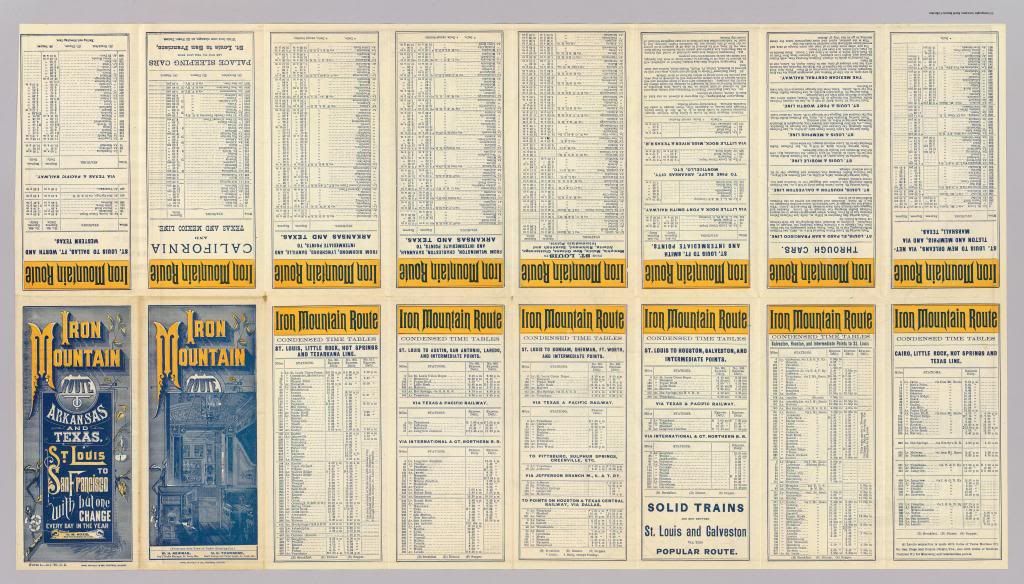
The David Rumsey collection did have a couple of handbills that had the schedule of the St. Louis, Iron Mountain, and Southern Railway digitized. One is from 1878 and the other is from 1886. The schedules were a condensed version of what is in the Travelers’ Guide, but has further details like the stop in Carondelet was on at the depot on Robert Avenue. The quality of the scans is quite impressive that gives great detail of the text on the handbills.
The next step in my prototype was to find out what industries were available and to incorporate them into the layout design. St. Louis was a major manufacturing town, in addition to being a way station for everyone going west, so it had an extensive section of warehouses by the railroad lines. Raw materials from like Des Arc and Piedmont’s lumber industry were sent north and south. In between De Soto and Des Arc, mining was a booming business that had miners extracting silver, lead, and iron from the mountains to end up in places like St. Louis for smelting and finished into boilers and other products. One of the biggest food commodities from the area was cattle ranching. The cattle were shipped north to slaughterhouses in St. Louis or they were slaughtered locally to be shipped to the big city. St. Louis has a further reputation, from this era, as being a big beer town. In the 1880s alone, there were over 40 different breweries and they all shipped beer to all over the United States. However, the two biggest giants were Lemp Brewery; Falstaff was their number one selling beer, and Anheuser-Busch, with their Budweiser. The competition between the two companies was fierce and that forced them to innovate to get their products safely to their customers.
With this list, I was able to come up with industries that made sense and fit the layout I want to do. Piedmont is home to the sawmill, Des Arc has a logging camp and a stockyard, Arcadia is where the beef is processed, Iron Mountain and Irondale each have an iron mine, Bismark has a small icing platform for the beer cars, Mineral Point is the location of a silver and lead mine, De Soto has a railroad car shop, and St. Louis will have Lemp Brewery, warehouses, a smelter, a lumberyard, and Plum Street Depot.
Industries
1. Passenger Service
2. Iron Mining
3. Silver Mining
4. Beer Brewing (Lemp and A-B)
5. General Merchandise
6. Lead Mining
7. Lumber
8. Stockyard
9. Slaughterhouse
From my experience, you can see that finding information about 19th century railroading is quite fun and easy to get. The information is there if you are willing to search for it. Thanks to companies like Google and others like the USGS, you can get all the information you need to accurately model a 19th century prototype. The amazing thing about doing the research is that a person is peering into the mists of the past to get a glimpse of what life was like back then.
Feel free to publish this in the magazine.